Drone-based Aerial Investigation of Crusader sites by Mathias Piana
The non-military use of unmanned aerial vehicles (UAV), commonly called “drones”, has undergone a rapid development during the recent years, with a major impact on both the professional and the consumer markets. Furnished with optical cameras and other imaging devices they grew to a serious tool for the airborne investigation of historic sites and landscapes, covering a wide range of disciplines, such as aerial photography and photogrammetry, digital land/object surveying and mapping, archaeological documentation, 3D modelling via structure-from-motion (SFM) procedures, infrared photography, and even LiDAR (Light detecting and ranging) scanning. Especially the latter provides the most instructive results, i.e. clear-cut contour maps in which vegetation and even buildings are eliminated at will. This technology enables a highly differentiated insight into surface structures revealing otherwise hidden features such as earlier river courses, ancient roads, fortification lines and moats, and traces of lost settlements.
Only few years ago the employment of these technologies required to operate from a helicopter or other manned aircraft, and to resort to heavy and expensive equipment. The latest generation of drones placed on the market make cutting-edge technology available now for a wider range of users. An ample selection of drones equipped with high quality cameras/scanners and automated flight routines give researchers the opportunity to map and investigate any type of historic landscape and/or settlement, providing informative results without great effort. This could make them an ideal tool for the assessment of medieval sites in the Levant, where there are restrictions of all kinds, requiring a low-profile approach.
Aerial Photography
Taking photographs from a higher perspective without great effort is one of the foremost advantages of drones. It allows not only creating orthophotos, which is especially useful in the documentation of excavation areas and archaeological sites, but also the inspection of features of buildings not accessible from the ground. It has proven its worth in taking close-ups of wall structures but also of more distant architectural elements. It is also a method for the documentation of interior walls of buildings (churches, halls etc.), even of those in narrow spaces like the interior of towers. A further intended use is to gain footage from otherwise inaccessible viewpoints, for example above water surfaces, dense vegetation zones, hillside locations or built-up areas. Although satellite imagery of almost any place in the world is now available for public use, there is still an advantage over aerial photography, as the former is too often not enough detailed or blurred. On the other hand, some applications such as Google Earth dispose of a history function offering a diachronic view.
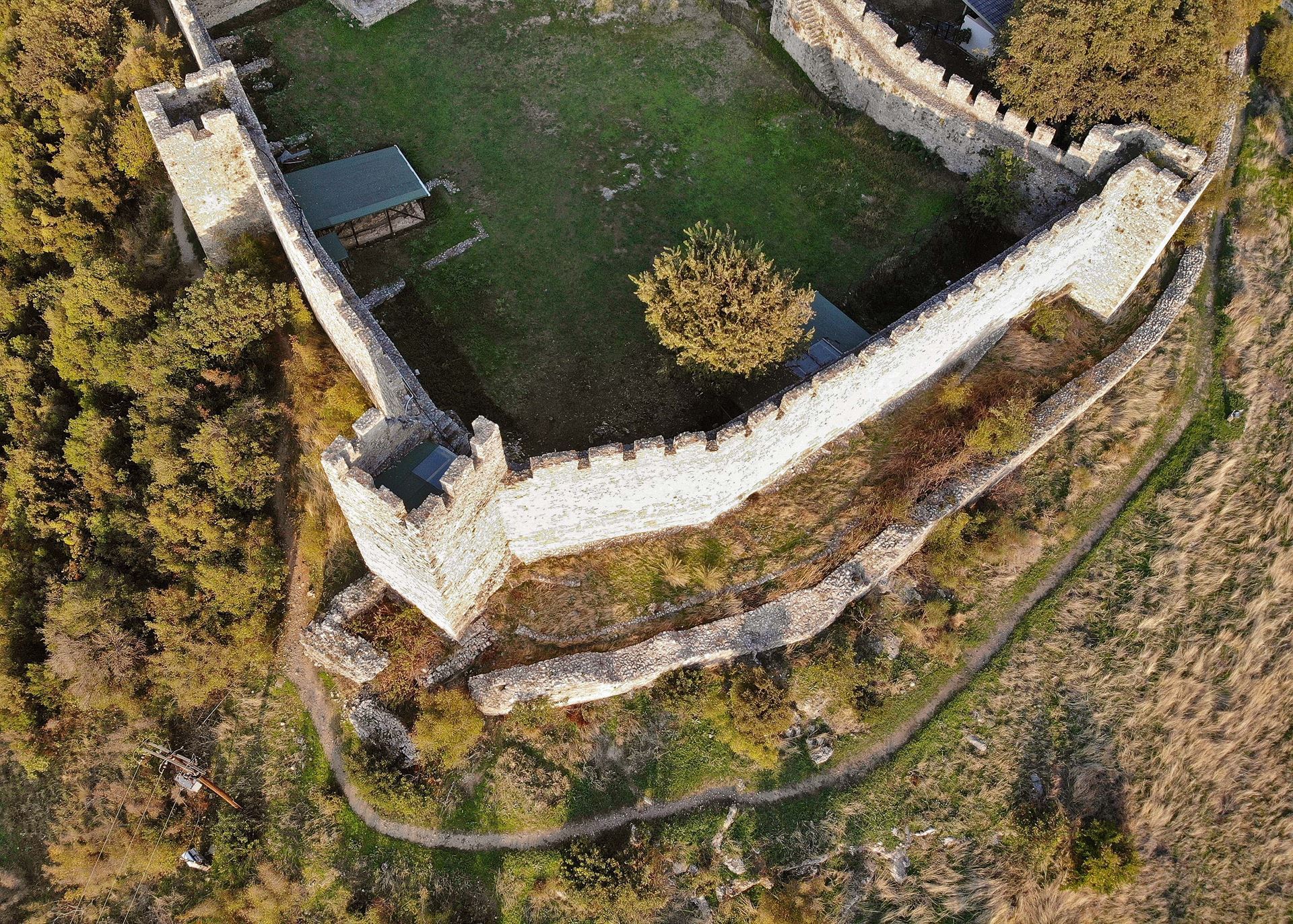
Fig. 1: Castle of Platamonas (Greece), aerial view into main wall/forewall scheme on the SW corner of the castle displaying different building phases
3D Modelling
During the last years, 3D modelling derived from photographs taken from different viewpoints around an object has become a quasi-standard, due to the limited conditions required and the convenient results. The structure-from-motion (SFM) software required for this procedure usually creates a point cloud which serves as a basis from which different 3D models are drawn. They are, however, always based on what is visible on the ground, for which reason they are best labelled as digital surface models (DSM). As photographs taken by drones are usually tagged with GPS data the models created from them are fully georeferenced and true to size. A much higher precision of the data collected and therefore of the models based on them is achieved by drones equipped with an RTK (real-time kinematographic) receiver. Thus the accuracy of GPS position data increases from several meters to 1-2 centimetres, which is in any case sufficient for the purpose of surveying and mapping historic sites and structures. Its advantage over conventional on-ground surveying is that the effort is reduced to a minimum, with no extra georeferencing needed. The latter is of great benefit in regions without an area-wide cadastral system providing fixed survey points, as is the case in most of the countries of the Eastern Mediterranean.
Furthermore, high resolution point clouds gained from these procedures allow taking any measurement required, straight away and with a high degree of exactness. Additionally, the processing in a CAD environment is only a few mouse clicks away. Time and effort spent on photogrammetry is likewise reduced, as elevation drawings may be drawn directly from the model or point cloud sections combined with photographs. In the same vein, any kind of sectional drawing can easily be extracted. Therefore, drone-based exploration may be especially useful at larger sites with rising structures, such as castles, churches or the like. For example, when the Crac des Chevaliers was surveyed in 2003 and 2005, it took all in all three months to accomplish the work, including photogrammetry. Using latest drone technology, combined with SFM procedures for internal spaces, would have reduced the effort by far, additionally providing georeferenced data which were not available back then.
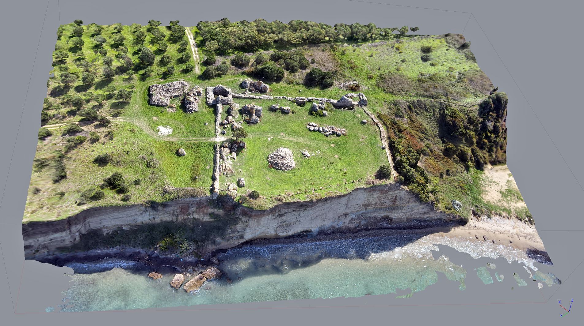
Fig. 2: Castle of Glarentza (Greece), 3D model, view from NW, visualizing topographical setting
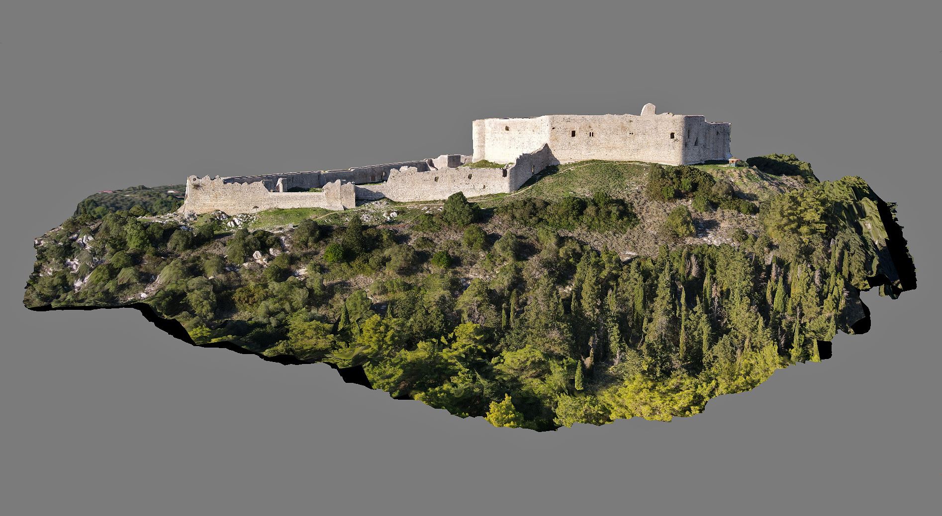
Fig. 3: Castle of Chlemoutsi (Greece), 3D model, orthoview from S
Digital Elevation Models (DEM) and Orthomosaics
The mapping of areas or objects with a set of photographs reproduces their surfaces, for which reason the 3D models created by this method are designated as digital surface models (DSM). Their quality depends on the resolution of the optical system used and the number of photographs taken. Detailed objects require shots from different angles and perspectives in order to create a model featuring all aspects. Given this they are particularly suited to document man-made structures in their present shape. Landscapes are impressively visualized. Sites within the landscape are contextualized making their topographical setting well conceivable. Therefore, the procedure is especially valuable for the documentation of mountainous areas and sites, which is often the case with medieval castles. It is a well-proven method to visualize the site selection of fortifications and settled areas in general, their topographical embedding and their relation to other features such as harbours, rivers and roads. This offers the opportunity to better assess the strategic and/or economic value of a site and its connection with communication lines. They may thus well be integrated in geographic information systems (GIS) for further analyses.
By reducing the DSM to 2D an orthophoto or orthomosaic is created. The advantage over aerial photography is that it is geometrically correct and free from distortion due to the terrain, perspective, camera tilt and the lenses used. It provides an accurate, true-to-scale image from which exact dimensions can be taken. This is especially useful for the mapping of areas containing visible remains of former settlements. By taking into account the height of any calculated point in the cloud digital elevation models (DEM) are produced. Displaying contour lines are an additional option, either in combination or without the underlying model. For a better visualization DEMs are usually displayed in false colours and with shading or as high contrast monochrome relief maps.
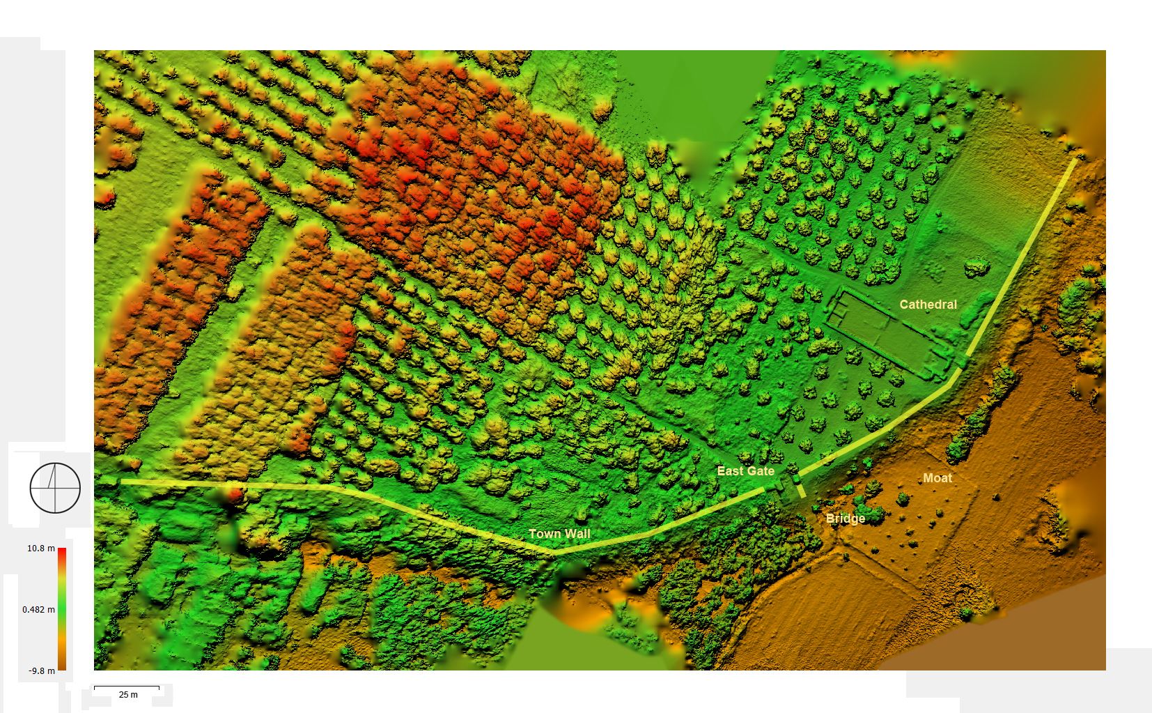
Fig. 4: Glarentza (Greece), digital surface model (DSM) of W section of Frankish town
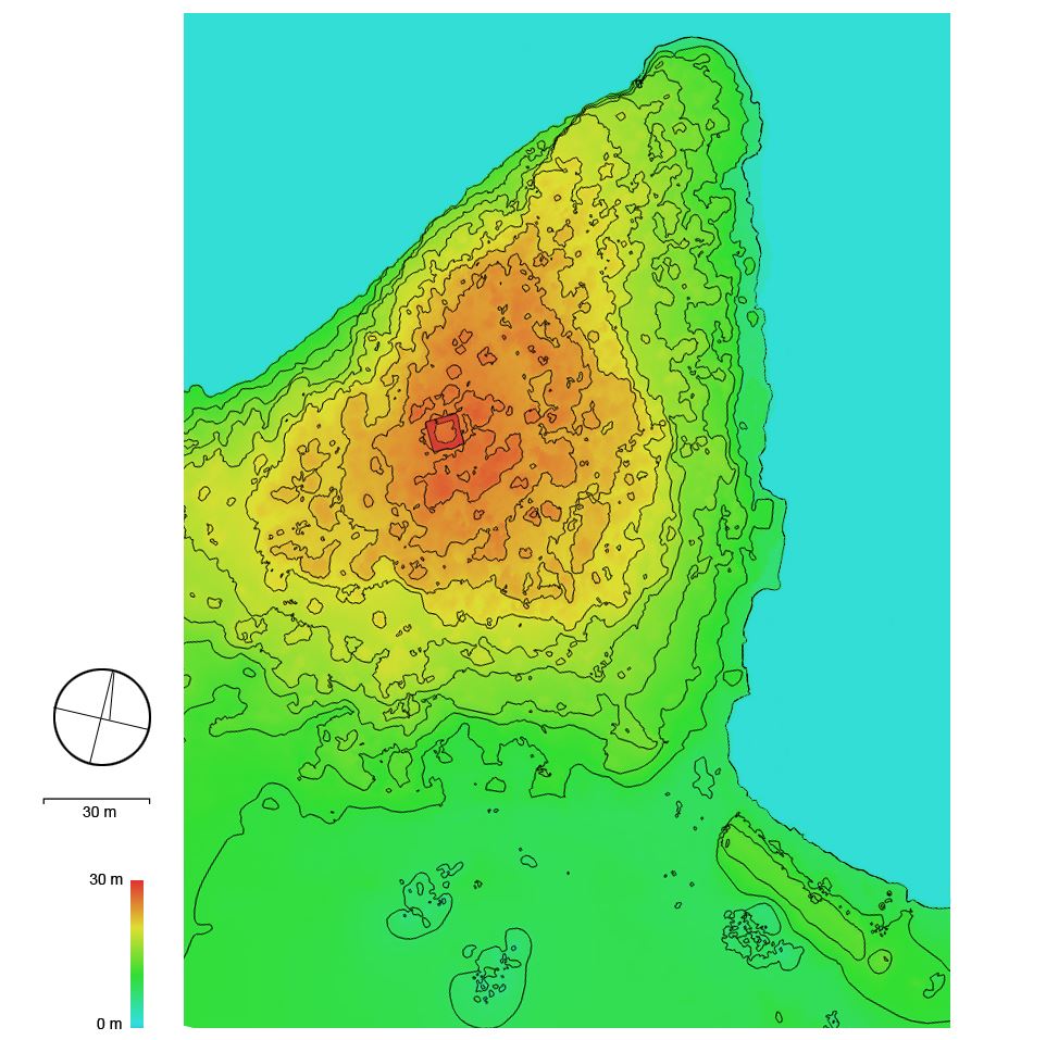
Fig. 5. Frankish Tower of Kounoupeli (Greece), digital elevation model (DEM) displaying contour lines
Drone-based LiDAR Scanning
The most elaborate feature available now for drone-based mapping is LiDAR (light detection and ranging) scanning. It uses laser light to produce high-resolution point clouds from which digital terrain models (DTM) and digital elevation models (DEM) of unprecedented accuracy and information content are produced. Its advantage over photography-based remote sensing is the ability to effectively eliminate reflections from vegetation and even from built-up fabric. The look through forest canopy and all kind of vegetation depicts the bare ground, revealing a wealth of information not detectable by any other method so far. This makes LiDAR scanning to an ideal tool for investigating historic sites and their layout without touching the ground. First steps were also made in the field of building research, where this technology was able to provide 3D models of unprecedented attention to detail and clearness. In the field of historical geography is used to expose ground walls of buildings, abandoned roads, settlement traces, and other man-made features otherwise not perceivable. In the case of fortifications previously unknown elements such as moats, forewalls, towers, wells, bridges, and even hidden outer wards of known castle sites are brought to light. This would make the method to an ideal tool for the mapping of the many medieval sites of the Levant which have hardly been explored yet. However, until now none of these has been investigated using this method. In the meantime, satellite imagery such as Google Earth etc. must suffice, even if the quality varies and the researcher has to deal with intentional blur and other impairments in several regions.
The State of Research in the Field
There have already been a series of airborne investigations at select sites all over the world. A case in point is the survey of Torre di Cisterna in Basilicata (Southern Italy), an 11th-century Byzantine town and castle of which only scarce remains are left, completely overgrown by vegetation. An extended aerial LiDAR survey of the site in 2014 demonstrated the avail offered by this method. By the implementation of different LiDAR-derived models (LDM) the structures in question were visualized in different ways, resulting in a well-defined digital terrain model (DTM) providing a wealth of information on the lost settlement and its layout.
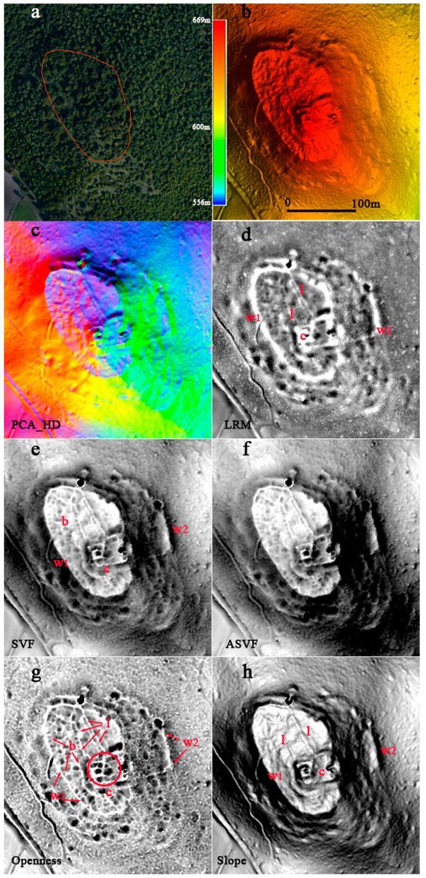
Fig. 6: Torre di Cisterna, Archaeological feature enhancement from LiDAR-derived models (LDM): c – castle, b – potential buildings, l – potential streets, w1/2 – town walls (source: Masini et al. 2018; license CC BY 4.0)
Turning to the medieval sites of the Eastern Mediterranean it appears that up to now only few projects were carried out using this technology. A remarkable first step in this direction is the website eCastles, established by the Ephorate of Antiquities of Argolid/Greece, where all fortified sites of the north-eastern Peloponnese (Argolis, Arcadia and Corinthia) were compiled. It comprises all known Frankish sites and provides, where available, instructive photogrammetric and 3D representations, based on aerial surveys. A project underlining the value of drone-based documentation was carried out at the castles of Acrocorinth and Penteskoufi (Peloponnese) in 2015, where otherwise inaccessible sections could be covered. At Acrocorinth for example, the comprehensive airborne survey addressed issues such as historical research and the organisation of excavations and restoration studies.
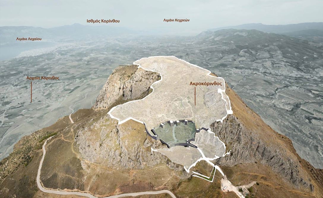
Fig. 7: Castle of Acrocorinth, visual reconstruction in the Middle Byzantine Period, view from W (source: eCastles)
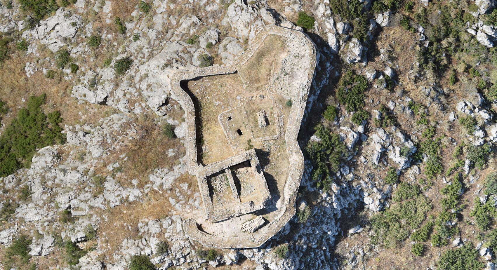
Fig. 8: Castle of Penteskoufi, orthomosaic (source: Imantosis)
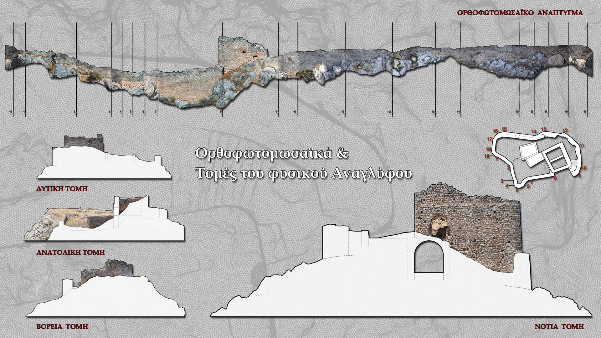
Fig. 9: Castle of Penteskoufi, elevation and section drawings (source: Imantosis)
Another project where drone-based photogrammetry was employed is the one conducted at the castle of Kyrenia/Cyprus in 2018. It resulted in a digital 3D model of the external parts of the castle and its surroundings, into which other digital survey data collected on the ground were integrated. A further project is planned focusing on the 3D documentation of principle monuments of the Principality of Achaea, of which the illustrations presented above may offer a first glimpse.
As the medieval sites of the Eastern Mediterranean are particularly endangered, not only by impact of conflicts but also by neglect, rapidly expanding settlement and inappropriate restoration, it is a major concern of cultural heritage conservation to document them comprehensively. Drone-based surveys would be an affordable, non-destructive, and thus appropriate way to achieve this. There is no doubt that this technology will not only change the way of surveying and documenting historic sites in the future but also pave the way for novel applications of investigating the related landscape. It is also a cost-effective way for the registration of the archaeological heritage.
(Illustrations by author, unless otherwise stated)